TOPOWIN 11.20
TOPOWIN is a state-wide register of the German topographic cartographies.
TOPOWIN is a state-wide register of the German topographic cartographies and of localities with geo references in different coordinate systems. It also is a topographic information system.
Software Specs
Publisher:............ C. Killet Software Ing.-GbR
License:............... Shareware
Price:................... $150.00
Expire: ................ 15
File size:.............. 3.34 MB
Downloads:.........
Release date:...... 07 Oct 2011
Last update:........ 07 Oct 2011
Language:............ German, English
Publisher review for TOPOWIN 11.20:
Review by: C. Killet Software Ing.-GbR
TOPOWIN is a state-wide register of the German Topographic Cartographies, the German Basic Cartography and of localities with geo references in different coordinate systems. It is also a topographic information system. In the division of planning and execution of economical and scientific projects frequently topographic documents are used. The program TOPOWIN makes information available of the official topographic cartographies and the German Basic Cartography from the entire national territory in suitable graphic views. It accomplishes different coordinate transformations and inquiries. The program was developed under co-operation of the land surveying authorities of many German Federal States. For the first time in the previous version TOPO (for DOS) and later in TOPOWIN state-wide topographic information were arranged for the data technical evaluation. The program is for consulting engineers, planning authorities and users of topographic maps a useful and versatile tool. The topographical maps of different standards, required for a project, can be determined by the entering of known parameters or by the direct selection from overview graphics and from sorted lists. By the investigation of topographical records on the basis of known places, a data base with more then 105.000 places and residential districts is available. The program TOPOWIN calculates with Gauss Krueger coordinates and Geographic Coordinates refering to the Potsdam Datum (Bessel ellipsoid with central point Rauenberg). It also works with UTM coordinates and UTMRef coordinates in the NATO standard, which refer to the datum ETRS89 (GRS80 / WGS84, geocentric).
Requirements:
500 MHz, 500 MB Memory, 100 MB HD
Operating system:
Win2000,Win7 x32,Win7 x64,Win98,WinMobile,WinOther,WinServer,WinVista,WinVista x64,WinXP
Whats new in version 11.20:
Datenstand auf den 5. Sept. 2011 aktualisiert (Kreis-Gebietsreform in Mecklenburg-Vorpommern). WIN-Vista und WIN-7 Zertifizierung erneuert. Programm mit modernem CHM-Hilfesystem ausgestattet. Neue Anschriften der Kartenlieferanten. Um 3500 Ortsteile auf ca. 119000 Datens�tze erg�nzt.

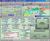
TOPOWIN screenshots:
TOPOWIN download tags:
topography geodetics geography corner box coordinate map guide TK25 TK50 TK50 TK100 TKUE200 GK5 DGK5 geo registers place topowin topo placelist information system measuring
Copyright information:
SPONSORED LINKS
Based on 1 ratings. 1 user reviews.
DBDesigner 4
DB-MAIN
SQL-Front
Full Convert Enterprise
PC-Telephone
Liquid Desktop
Advanced Access Repair
Oraspeed SQL Editor
ERD Concepts
Accounting and Finance
Office Suites and Tools
Inventory and Barcoding
PIMS and Calendars
Databases and Tools
Project Management
Helpdesk and Remote PC
Calculators and Converters
Vertical Market Apps
Investment Tools
Math and Scientific Tools
Other
Timesheets MTS Software
Softvoile
NewFreeDownloads
Office Suites
PIMS
Math
Calculators
Helpdesk
Databases
Accounting
Inventory